
The Name: Saint Lucia
|
The Name: Saint Lucia |
|
The
Amerinidians, who were found inhabiting the island when the first Europeans
landed, called the island ‘IOUANALAO’.
According to the Dominican missionary, Pere Raymond Breton who, sometime
around 1650, composed a dictionary of the Amerindian language, that name is
purported to mean “There where the Iguana is found”. When the Caribs
pretended to sell the island to the Barbadians in 1663, the name they used was ‘HEWANORRA’,
which makes one historian, Douglas Taylor, conclude that the name was of
Arawak and not of Carib origin.
Despite the mystery and myth about discovery and names, Saint Lucians have decided to celebrate 13th December as their National Day.
LOCATION & GEOGRAPHY:
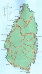
Saint Lucia is an island located in the windward group of islands in the Caribbean Sea. The island is of volcanic origin with high lava ridges and craters. St. Lucia has a mountainous center reaching the country's highest point Mt. Gimie at 959 metres (3,146 feet). Tropical rain forests cover the interior and a number of small rivers flow from the central highlands with the principal ones being the Dennery, Fond, Piaye, Doree, Canaries, Roseau and Marquis Rivers. |
|
© 2013 Government of Saint Lucia. All rights reserved. |

 Much
of Saint Lucia’s early history is shrouded in mystery and myth. It is now
known, for example, that Columbus never set foot in Saint Lucia during any of
his voyages.
Much
of Saint Lucia’s early history is shrouded in mystery and myth. It is now
known, for example, that Columbus never set foot in Saint Lucia during any of
his voyages.